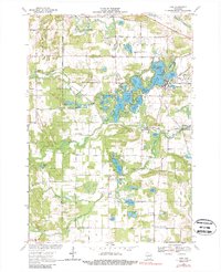
1969 Map of King
USGS Topo · Published 1988About this map
The glacial kettle lakes of central Wisconsin define the landscape in this late 1960s survey, dominated by a dense chain of water bodies including Rainbow Lake, Sunset Lake, and Columbia Lake. These interconnected waters surround Government Island and Onaway Island, creating a complex shoreline that supported early recreation and religious retreats such as the Blessed Sacrament of Fathers Sch and the Waupaca Boys Camp. Near the western edge, the newly established Hartman Creek State Park preserves the moraine terrain around Marl Lake and Pope Lake.
Find a feature on this map
69 named features on this map. Tap any name to fly to it.
Don’t see what you’re looking for? This feature index may not catch every label — zoom into the map to look around manually.
Map Details
Editions of this 1969 King Map
2 editions found
Other maps of this area

1955 · Green Bay
USGS Topo · 1:250,000

1957 · Amherst
USGS Topo · 1:48,000

1957 · Waupaca
USGS Topo · 1:48,000

1959 · Wautoma
USGS Topo · 1:48,000

1961 · Redgranite
USGS Topo · 1:62,500

1961 · Saxeville
USGS Topo · 1:24,000

1961 · Wild Rose
USGS Topo · 1:24,000
1968 · Wautoma NE
USGS Topo · 1:24,000
1969 · Waupaca
USGS Topo · 1:24,000
1969 · King
USGS Topo · 1:24,000