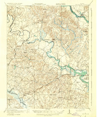
1920 Map of King William
USGS Topo · Published 1937About this map
The Pamunkey River and Mattaponi River define the tidewater landscape of this region during the years following the first World War. At the heart of the terrain lies the Pamunkey Indian Reservation, situated on a prominent bend of the river near White House. The map documents a rural economy transitioning from water-based transport to rail, evidenced by the Southern railroad line crossing the landscape and older landmarks like the Piping Tree Ferry and Newcastle Bridge. Numerous local milling sites, such as Crumps Mill and Parsleys Mill, suggest a landscape of small-scale industry and family-owned lands. Scattered crossroads settlements like King William and Talleysville serve as hubs for social life, anchored by landmarks such as St Peters Church and several rural schools including the Second Liberty School.
Find a feature on this map
71 named features on this map. Tap any name to fly to it.
Don’t see what you’re looking for? This feature index may not catch every label — zoom into the map to look around manually.
Map Details
Editions of this 1920 King William Map
4 editions found

Other maps of this area

1894 · Bermuda Hundred
USGS Topo · 1:62,500

1894 · Richmond
USGS Topo · 1:62,500

1895 · Richmond
USGS Topo · 1:62,500

1917 · Toano
USGS Topo · 1:62,500

1918 · Charles City
USGS Topo · 1:62,500

1918 · Toano
USGS Topo · 1:62,500

1918 · Doswell
USGS Topo · 1:62,500

1918 · Tappahannock
USGS Topo · 1:62,500

1918 · Aylett
USGS Topo · 1:62,500

1919 · New Kent
USGS Topo · 1:62,500