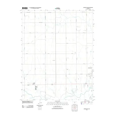
2012 Map of Kingman NW
USGS Topo · Published 2012About this map
S Fork Ninnescah River meanders across the southern portion of this landscape northwest of Kingman, defining the local drainage pattern along with Smoots Cr and Petyt Cr. The map reveals a transition from a traditional agricultural grid to localized industrial and transportation development. The presence of Browns Spur indicates a historic rail-related location, while Kingman Airport - Clyde Cessna Field anchors the southeastern corner, signifying the area's modern aviation connections. Genealogists will find the Hoosier Cem positioned centrally among the established section lines. The terrain is marked by a network of rural routes such as W Maple Grove Rd and Smoots Creek Rd, which provide access to the various farmsteads and water bodies like Beck Lake.
Find a feature on this map
39 named features on this map. Tap any name to fly to it.
Don’t see what you’re looking for? This feature index may not catch every label — zoom into the map to look around manually.
Map Details
Editions of this 2012 Kingman NW Map
This is the sole edition of this map. No revisions or reprints were ever made.
Other maps of this area

1892 · Kingman
USGS Topo · 1:125,000

1894 · Kingman
USGS Topo · 1:125,000

1955 · Pratt
USGS Topo · 1:250,000

1959 · Pratt
USGS Topo · 1:250,000

1967 · Kingman NW
USGS Topo · 1:24,000
1967 · Alameda
USGS Topo · 1:24,000

1967 · Cleveland
USGS Topo · 1:24,000
1967 · Kingman
USGS Topo · 1:24,000
1967 · Willowdale
USGS Topo · 1:24,000

1967 · Penalosa
USGS Topo · 1:24,000