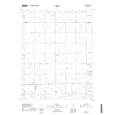
2018 Map of Kingman NW
USGS Topo · Published 2018About this map
Kingman serves as the primary hub of this south-central Kansas landscape, situated near the eastern edge of the survey area. The town’s spatial organization is defined by its street grid, featuring W Kansas Ave and W Wallace Ave, and its proximity to the South Fork Ninnescah River. Just northwest of the main settlement lies the Kingman Airport - Clyde Cessna Field, a notable aviation landmark for the region. The surrounding countryside is primarily defined by its drainage systems and agricultural sections, with Smoots Cr and Petet Cr winding through the terrain. A small pocket of local history is preserved at the Hoosier Cem, located centrally within the rural sections north of the river. The southern reaches are marked by Back Lake, providing a distinct contrast to the otherwise uniform section lines and rural road networks.
Find a feature on this map
30 named features on this map. Tap any name to fly to it.
Don’t see what you’re looking for? This feature index may not catch every label — zoom into the map to look around manually.
Map Details
Editions of this 2018 Kingman NW Map
This is the sole edition of this map. No revisions or reprints were ever made.
Other maps of this area

1892 · Kingman
USGS Topo · 1:125,000

1894 · Kingman
USGS Topo · 1:125,000

1955 · Pratt
USGS Topo · 1:250,000

1959 · Pratt
USGS Topo · 1:250,000

1967 · Kingman NW
USGS Topo · 1:24,000
1967 · Alameda
USGS Topo · 1:24,000

1967 · Cleveland
USGS Topo · 1:24,000
1967 · Kingman
USGS Topo · 1:24,000
1967 · Willowdale
USGS Topo · 1:24,000

1967 · Penalosa
USGS Topo · 1:24,000