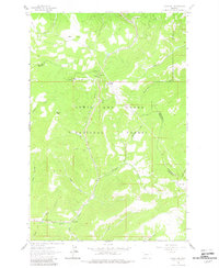
1961 Map of Kings Hill
USGS Topo · Published 1982About this map
The Lewis and Clark National Forest defines this high-elevation landscape, where the intersection of three counties — Cascade, Meagher, and Judith Basin — meets in the mountain peaks. This 1961 field-checked survey reveals the area as a dedicated recreational hub, centered on the Kings Hill Winter Sports Area and its associated Ski Lift. These facilities, situated near the 7,393-foot Kings Hill Pass, mark a period when the mountain was established for regional winter tourism along U.S. 89.
Find a feature on this map
37 named features on this map. Tap any name to fly to it.
Don’t see what you’re looking for? This feature index may not catch every label — zoom into the map to look around manually.
Map Details
Editions of this 1961 Kings Hill Map
2 editions found
Other maps of this area

1886 · Little Belt Mts.
USGS Topo · 1:250,000

1894 · Little Belt Mts.
USGS Topo · 1:250,000

1897 · Little Belt Mts.
USGS Topo · 1:250,000

1898 · Little Belt Mts.
USGS Topo · 1:250,000

1902 · Little Belt Mts.
USGS Topo · 1:250,000

1948 · White Sulphur Springs
USGS Topo · 1:250,000

1958 · White Sulphur Springs
USGS Topo · 1:250,000

1961 · White Sulphur Springs
USGS Topo · 1:250,000
1961 · Kings Hill
USGS Topo · 1:24,000
1961 · Neihart
USGS Topo · 1:24,000