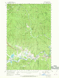
1957 Map of Kingston
USGS Topo · Published 1970About this map
The Cataldo Mission stands as a primary landmark in this valley, situated on the Mission Flats where the Coeur d'Alene River meets the confluence of the North Fork Coeur d'Alene River. This 1957 field-checked survey reveals a landscape defined by the intersection of early transport and rugged topography. The Union Pacific railroad tracks follow the river's path, serving the settlements of Kingston, Cataldo, and Rose Lake. To the north, the terrain rises into the Coeur d'Alene National Forest, marked by peaks such as Monument Mtn and Skitwish Peak. The presence of the Canyon School and an Airway Beacon near Fourth of July Canyon illustrates the infrastructure of the mid-century era, balancing local education needs with the growing requirements of aerial navigation across the Idaho panhandle.
Find a feature on this map
91 named features on this map. Tap any name to fly to it.
Don’t see what you’re looking for? This feature index may not catch every label — zoom into the map to look around manually.
Map Details
Editions of this 1957 Kingston Map
3 editions found
Other maps of this area

1903 · Rathdrum
USGS Topo · 1:125,000

1909 · Cataldo
USGS Topo · 1:125,000

1911 · Cataldo
USGS Topo · 1:125,000

1950 · Rochat Peak
USGS Topo · 1:24,000

1950 · Twin Crags
USGS Topo · 1:24,000

1952 · Rochat Peak
USGS Topo · 1:24,000

1952 · Twin Crags
USGS Topo · 1:24,000

1955 · Spokane
USGS Topo · 1:250,000

1957 · St. Maries
USGS Topo · 1:62,500

1957 · Kingston
USGS Topo · 1:62,500