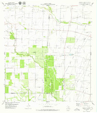
1979 Map of Kingsville NW
USGS Topo · Published 1979About this map
Agua Dulce Oil and Gas Field dominates the industrial character of this landscape in the late 1970s. This territory, situated at the intersection of Jim Wells, Nueces, and Kleberg counties, is defined by an extensive network of extraction infrastructure including numerous Oil Wells, Gas Wells, and complex systems of pipelines. The map captures a transition between heavy energy production and traditional ranching or agriculture, evidenced by several family-named or ranch landmarks such as Magnolia Windmill, Gato Windmill, and Morgan Windmill. Waterways like San Fernando Creek and Pintas Creek wind through the terrain, providing natural drainage amidst a grid of access roads and industrial sites including a Refinery and a Pumping Sta. The proximity of county boundaries suggests a region where local governance and land use were heavily influenced by the sub-surface resources and the infrastructure required to transport them.
Find a feature on this map
17 named features on this map. Tap any name to fly to it.
Don’t see what you’re looking for? This feature index may not catch every label — zoom into the map to look around manually.
Map Details
Editions of this 1979 Kingsville NW Map
This is the sole edition of this map. No revisions or reprints were ever made.
Other maps of this area

1917 · Ben Bolt
USGS Topo · 1:62,500

1920 · San Diego
USGS Topo · 1:62,500

1950 · Corpus Christi
USGS Topo · 1:250,000

1954 · Orange Grove
USGS Topo · 1:62,500

1954 · Kingsville
USGS Topo · 1:62,500

1956 · Corpus Christi
USGS Topo · 1:250,000

1956 · Laredo
USGS Topo · 1:250,000

1960 · Corpus Christi
USGS Topo · 1:250,000

1963 · Ben Bolt SE
USGS Topo · 1:24,000
1963 · Alice North
USGS Topo · 1:24,000