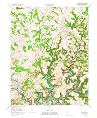
1963 Map of Kingswood
USGS Topo · Published 1964About this map
Rough River Reservoir dominates the southern landscape of this Breckinridge County study, where the winding North Fork Rough River meets a network of deeply incised creeks. The map documents the mid-century rural infrastructure of the region, anchored by small community centers like Kingswood, Westview, and Harned. Genealogists and local researchers will find significant markers of rural life, including St Anthony Sch and several country churches such as Mt Zion Ch, Cave Spring Ch, and Sand Knob Ch. The terrain is characterized by sharp elevation changes between the upland ridges where oil wells are scattered and the lower inundated basins of the reservoir system. The detailed mapping of Tules Creek, Buffalo Creek, and Long Creek illustrates the complex drainage patterns that shaped local settlement before the reservoir's controlled inundation levels were established.
Find a feature on this map
23 named features on this map. Tap any name to fly to it.
Don’t see what you’re looking for? This feature index may not catch every label — zoom into the map to look around manually.
Map Details
Editions of this 1963 Kingswood Map
3 editions found
Other maps of this area

1928 · Hardinsburg
USGS Topo · 1:48,000

1931 · Hardinsburg
USGS Topo · 1:62,500

1932 · Fordsville
USGS Topo · 1:62,500

1934 · Cannelton
USGS Topo · 1:62,500

1947 · Hardinsburg
USGS Topo · 1:24,000

1947 · Garfield
USGS Topo · 1:24,000

1947 · Hardinsburg
USGS Topo · 1:62,500

1953 · Custer
USGS Topo · 1:24,000

1953 · Mc Daniels
USGS Topo · 1:24,000

1953 · Hardinsburg
USGS Topo · 1:24,000