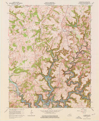
1963 Map of Kingswood
USGS Topo · Published 1976About this map
Kingswood sits atop the high ground between the deep drainage of the North Fork Rough River and the undulating uplands leading toward Harned. This 1960s revision captures the landscape just as the Rough River Lake reservoir had reshaped the local geography, with the water level noted at its normal pool elevation of 490. The area is characterized by a network of small creeks like Tules Creek and Lick Creek that carve through the limestone terrain, leading to features such as Cave Spring and Bens Hole.
Find a feature on this map
45 named features on this map. Tap any name to fly to it.
Don’t see what you’re looking for? This feature index may not catch every label — zoom into the map to look around manually.
Map Details
Editions of this 1963 Kingswood Map
3 editions found
Other maps of this area

1928 · Hardinsburg
USGS Topo · 1:48,000

1931 · Hardinsburg
USGS Topo · 1:62,500

1932 · Fordsville
USGS Topo · 1:62,500

1934 · Cannelton
USGS Topo · 1:62,500

1947 · Hardinsburg
USGS Topo · 1:24,000

1947 · Garfield
USGS Topo · 1:24,000

1947 · Hardinsburg
USGS Topo · 1:62,500

1953 · Custer
USGS Topo · 1:24,000

1953 · Mc Daniels
USGS Topo · 1:24,000

1953 · Hardinsburg
USGS Topo · 1:24,000