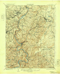
1925 Map of Kingwood
USGS Topo · Published 1932About this map
The Cheat River carves a winding path through this corner of West Virginia, defining a landscape of sharp ridges and narrow bottoms in the 1920s. Centered around the county seat of Kingwood, the map details a region where transport was dictated by the river and the demanding geography of Briery Mountain. The Baltimore and Ohio RR snakes alongside the river and through critical junctions like Rowlesburg and Tunnelton, while historic routes like the Northwestern Virginia Turnpike and Morgantown Turnpike provide overland connections. Rural life is meticulously documented through a high density of country schools and churches, such as the Sister School and Snider Church, reflecting the decentralized settlement patterns of the era. The presence of Lake Terra Alta and the nearby Hopemont sanitarium near the Maryland border highlights the area's development beyond its agricultural and timber roots.
Find a feature on this map
104 named features on this map. Tap any name to fly to it.
Don’t see what you’re looking for? This feature index may not catch every label — zoom into the map to look around manually.
Map Details
Editions of this 1925 Kingwood Map
3 editions found

Other maps of this area

1886 · St. George
USGS Topo · 1:125,000

1891 · St. George
USGS Topo · 1:125,000

1895 · Piedmont
USGS Topo · 1:125,000

1899 · Oakland
USGS Topo · 1:62,500

1900 · Accident
USGS Topo · 1:62,500

1900 · Oakland
USGS Topo · 1:62,500

1902 · Morgantown
USGS Topo · 1:62,500

1904 · Bruceton
USGS Topo · 1:62,500

1907 · Thornton
USGS Topo · 1:62,500

1907 · Kingwood
USGS Topo · 1:62,500