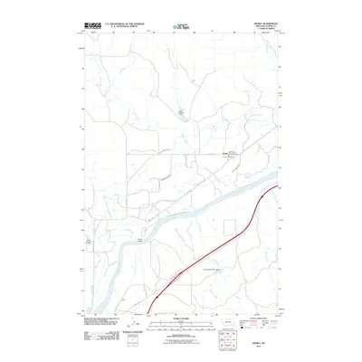
2011 Map of Kinsey
USGS Topo · Published 2011About this map
The Yellowstone River cuts a wide path through this Custer County landscape, defining the agricultural and civic layout of the Kinsey area. An extensive irrigation network, including the Kinsey Highline Canal, Kinsey Middle Canal, and Kinsey Lower Canal, supports the valley floor, while the surrounding upland is marked by intermittent drainages like Muster Creek and Sand Creek. The settlement of Kinsey serves as the local hub, anchored by the Kinsey Post Office and the Kinsey Rural Vol Fire Company Kinsey. Near the river's bend, the Kinsey Bridge provides a vital crossing point, linking the primary community with southern routes and the rail-adjacent area near Tusler. Water management is further evidenced by several small impoundments such as the Watts Number 1 Dam and Stiles Number 1 Dam, which sit among the draws and coulees.
Find a feature on this map
27 named features on this map. Tap any name to fly to it.
Don’t see what you’re looking for? This feature index may not catch every label — zoom into the map to look around manually.
Map Details
Editions of this 2011 Kinsey Map
This is the sole edition of this map. No revisions or reprints were ever made.
Other maps of this area

1953 · Miles City
USGS Topo · 1:250,000

1957 · Miles City
USGS Topo · 1:250,000

1958 · Miles City
USGS Topo · 1:250,000

1968 · Miles City
USGS Topo · 1:24,000

1969 · Noble Reservoir
USGS Topo · 1:24,000

1969 · Kinsey NE
USGS Topo · 1:24,000
1969 · Coal Bank Spring
USGS Topo · 1:24,000

1969 · Kinsey
USGS Topo · 1:24,000

1969 · Government Hill
USGS Topo · 1:24,000

1969 · The Knob
USGS Topo · 1:24,000