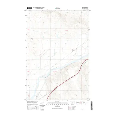
2014 Map of Kinsey
USGS Topo · Published 2014About this map
The Yellowstone River carves a significant path through this landscape, defining the geographic and economic character of the region. The settlement of Kinsey serves as a focal point for an extensive irrigation network, with the Kinsey Middle Canal, Kinsey Lower Canal, and Kinsey Highline Canal branching out to manage water resources across the valley. This system of canals suggests a deeply rooted agricultural history reliant on river diversion. To the southwest, the community of Tusler sits near the riverbanks, where geographic features like Buffalo Rapids and Dixons Rapids indicate the river's natural turbulence and navigational challenges. Transport across the water is anchored by the Kinsey Bridge, while a network of rural roads such as Lower Rd and Tusler Rd connects the scattered homesteads and irrigation works. Numerous drainages, including Muster Cr and Dixon Cr, feed into the main river valley from the surrounding uplands.
Find a feature on this map
33 named features on this map. Tap any name to fly to it.
Don’t see what you’re looking for? This feature index may not catch every label — zoom into the map to look around manually.
Map Details
Editions of this 2014 Kinsey Map
This is the sole edition of this map. No revisions or reprints were ever made.
Other maps of this area

1953 · Miles City
USGS Topo · 1:250,000

1957 · Miles City
USGS Topo · 1:250,000

1958 · Miles City
USGS Topo · 1:250,000

1968 · Miles City
USGS Topo · 1:24,000

1969 · Noble Reservoir
USGS Topo · 1:24,000

1969 · Kinsey NE
USGS Topo · 1:24,000
1969 · Coal Bank Spring
USGS Topo · 1:24,000

1969 · Kinsey
USGS Topo · 1:24,000

1969 · Government Hill
USGS Topo · 1:24,000

1969 · The Knob
USGS Topo · 1:24,000