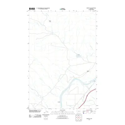
2011 Map of Kinsey NE
USGS Topo · Published 2011About this map
The Yellowstone River cuts through this portion of Custer County, shaping a landscape of agricultural water management and historical passage. Water infrastructure is central to the area's development, evidenced by the Shirley Main Canal and several rural reservoirs such as the Haughian Number 12 Dam and Custer Creek Dam. These features illustrate the vital role of irrigation and water storage in the high plains. Small rail-side locations like Bonfield and Benz mark the transport corridor along the southern bank, while the Lewis and Clark Trl follows the river's path, connecting the modern map to the era of western exploration. To the north, the terrain becomes increasingly complex as it rises toward the Devils Backbone, with numerous drainages including Saugus Creek and Custer Creek feeding into the main river valley.
Find a feature on this map
15 named features on this map. Tap any name to fly to it.
Don’t see what you’re looking for? This feature index may not catch every label — zoom into the map to look around manually.
Map Details
Editions of this 2011 Kinsey NE Map
This is the sole edition of this map. No revisions or reprints were ever made.
Other maps of this area

1953 · Miles City
USGS Topo · 1:250,000

1957 · Miles City
USGS Topo · 1:250,000

1958 · Miles City
USGS Topo · 1:250,000

1969 · Corral Butte
USGS Topo · 1:24,000

1969 · Zero
USGS Topo · 1:24,000

1969 · Kinsey NE
USGS Topo · 1:24,000

1969 · Kinsey
USGS Topo · 1:24,000
1969 · Shirley
USGS Topo · 1:24,000
1969 · Kinsey NW
USGS Topo · 1:24,000

1972 · Calypso
USGS Topo · 1:24,000