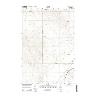
2014 Map of Kinsey NE
USGS Topo · Published 2014About this map
The Yellowstone River cuts a wide path through this corner of eastern Montana, where the irrigated lowlands meet the high, dissected prairie. Near the southern bank, the settlement of Bonfield sits along the rail line, while the Shirley Main Canal distributes water through the valley to support local agriculture. The topography is defined by the sharp transition from the river bottom to the uplands, marked by the narrow ridge of Devils Backbone. Further north, the landscape is deeply etched by ephemeral drainage systems like Gate Coulee and Yellowstone Coulee, which draw toward the river. Local transportation is facilitated by named routes such as Milwaukee Rd and Finneman Rd, crossing the boundary between Prairie and Custer counties.
Find a feature on this map
21 named features on this map. Tap any name to fly to it.
Don’t see what you’re looking for? This feature index may not catch every label — zoom into the map to look around manually.
Map Details
Editions of this 2014 Kinsey NE Map
This is the sole edition of this map. No revisions or reprints were ever made.
Other maps of this area

1953 · Miles City
USGS Topo · 1:250,000

1957 · Miles City
USGS Topo · 1:250,000

1958 · Miles City
USGS Topo · 1:250,000

1969 · Corral Butte
USGS Topo · 1:24,000

1969 · Zero
USGS Topo · 1:24,000

1969 · Kinsey NE
USGS Topo · 1:24,000

1969 · Kinsey
USGS Topo · 1:24,000
1969 · Shirley
USGS Topo · 1:24,000
1969 · Kinsey NW
USGS Topo · 1:24,000

1972 · Calypso
USGS Topo · 1:24,000