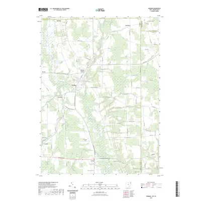
2023 Map of Kinsman
USGS Topo · Published 2023About this map
Pymatuning Creek and Stratton Creek carve through this corner of Trumbull County, where the village of Kinsman serves as a historic center at the junction of several regional routes. The map documents a landscape deeply rooted in the nineteenth-century settlement patterns of the Connecticut Western Reserve, evidenced by a high density of family and community burial grounds including New Kinsman Cem, Pioneer Cem, and the State Line Cem positioned on the border with Pennsylvania. To the south, Vernon and Farmdale represent quiet agricultural hubs, while Kinsman Lake provides a central water feature near the town center. The terrain rises toward Trautman Hill in the southeast, contrasting with the wetlands along the creek bottoms. Small airstrips like Flemming Field and named heights like Trautman Hill further define the local geography in this contemporary 2023 survey.
Find a feature on this map
45 named features on this map. Tap any name to fly to it.
Don’t see what you’re looking for? This feature index may not catch every label — zoom into the map to look around manually.
Map Details
Editions of this 2023 Kinsman Map
This is the sole edition of this map. No revisions or reprints were ever made.
Other maps of this area

1905 · Andover
USGS Topo · 1:48,000

1906 · Linesville
USGS Topo · 1:62,500

1907 · Andover
USGS Topo · 1:62,500

1907 · Kinsman
USGS Topo · 1:62,500

1908 · Shenango
USGS Topo · 1:62,500

1908 · Linesville
USGS Topo · 1:62,500

1950 · Cleveland
USGS Topo · 1:250,000

1956 · Cleveland
USGS Topo · 1:250,000

1958 · Sharpsville
USGS Topo · 1:24,000

1958 · Greensville West
USGS Topo · 1:24,000