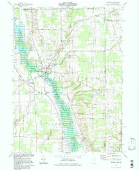
1994 Map of Kinsman
USGS Topo · Published 1997About this map
Kinsman sits as the central hub of this eastern Ohio landscape, where the waters of Stratton Creek meet Pymatuning Creek before flowing south into the expansive Pymatuning State Wildlife Area. This 1990s update, based on 1960s topography, reveals a rural network defined by family-named crossroads and small-scale agriculture. The settlement pattern is anchored by locations like Farmdale (Kinsman Sta), reflecting the earlier rail influence, and educational centers like Badger High Sch.
Find a feature on this map
61 named features on this map. Tap any name to fly to it.
Don’t see what you’re looking for? This feature index may not catch every label — zoom into the map to look around manually.
Map Details
Editions of this 1994 Kinsman Map
This is the sole edition of this map. No revisions or reprints were ever made.
Other maps of this area

1905 · Andover
USGS Topo · 1:48,000

1906 · Linesville
USGS Topo · 1:62,500

1907 · Andover
USGS Topo · 1:62,500

1907 · Kinsman
USGS Topo · 1:62,500

1908 · Shenango
USGS Topo · 1:62,500

1908 · Linesville
USGS Topo · 1:62,500

1950 · Cleveland
USGS Topo · 1:250,000

1956 · Cleveland
USGS Topo · 1:250,000

1958 · Sharpsville
USGS Topo · 1:24,000

1958 · Greensville West
USGS Topo · 1:24,000