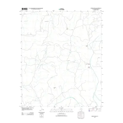
2012 Map of Kiowa Peak
USGS Topo · Published 2012About this map
The Brazos River and its tributary, the Salt Fork Brazos River, carve through this section of Stonewall County, creating a landscape of prominent breaks and canyons. This 2012 survey illustrates a terrain defined by elevations like Kiowa Peak and Davidson Peak, which rise above the surrounding drainage basins of Wedington Cr and Wilfong Cr. Significant for its local water sources, the area features Beaver Springs and the natural catchments of Keller Lake. Economic activity is represented by the Kiowa Park Oil Field in the northern portion of the quadrangle, while local transit is facilitated by a network of county roads leading to landmarks like Two F Crossing. The transition from the high peaks into Panther Canyon and Beaver Canyon demonstrates the erosional forces typical of the Rolling Plains region.
Find a feature on this map
18 named features on this map. Tap any name to fly to it.
Don’t see what you’re looking for? This feature index may not catch every label — zoom into the map to look around manually.
Map Details
Editions of this 2012 Kiowa Peak Map
This is the sole edition of this map. No revisions or reprints were ever made.
Other maps of this area

1925 · Aspermont 4-a
USGS Topo · 1:48,000

1925 · Haskell 3-b
USGS Topo · 1:48,000

1931 · Aspermont
USGS Topo · 1:62,500

1954 · Lubbock
USGS Topo · 1:250,000

1954 · Wichita Falls
USGS Topo · 1:250,000

1958 · Wichita Falls
USGS Topo · 1:250,000

1962 · Kiowa Peak
USGS Topo · 1:24,000

1965 · Jud
USGS Topo · 1:24,000

1967 · Knox City NW
USGS Topo · 1:24,000

1967 · Kiowa Peak NW
USGS Topo · 1:24,000