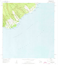
1957 Map of Kipahulu
USGS Topo · Published 1974About this map
The settlement of Kipahulu and its coastal surroundings are captured here at the mid-century, following a 1957 field check. The landscape is defined by the steep transition from the Hana Forest Reserve and Kipahulu Forest Reserve down to the rocky coastline of the Alenuihaha Channel. This area preserves significant cultural and physical landmarks, including the Kanekauila Heiau and a Historical Monument near the coast. The Hana Highway provides the primary artery through small communities like Puuiki, Koali, and Wailua. Interior drainages are marked by dramatic water features such as Wailua Falls, Waimoku Falls, and the Kekua poowai Falls, while the shoreline is punctuated by Old Landing and the Seven Pools at Kuloa Pt. This survey details the complex network of gulches, including Oheo Gulch and Puaaluu Gulch, that carve the volcanic terrain.
Find a feature on this map
73 named features on this map. Tap any name to fly to it.
Don’t see what you’re looking for? This feature index may not catch every label — zoom into the map to look around manually.
Map Details
Editions of this 1957 Kipahulu Map
2 editions found
Other maps of this area

1954 · Maui
USGS Topo · 1:250,000

1957 · Kipahulu
USGS Topo · 1:24,000

1957 · Hana
USGS Topo · 1:24,000

1957 · Nahiku
USGS Topo · 1:24,000

1957 · Kaupo
USGS Topo · 1:24,000

1966 · Maui
USGS Topo · 1:250,000

1974 · Maui
USGS Topo · 1:250,000

1978 · Hana
USGS Topo · 1:24,000

1983 · Nahiku
USGS Topo · 1:24,000
1983 · Kaupo
USGS Topo · 1:24,000