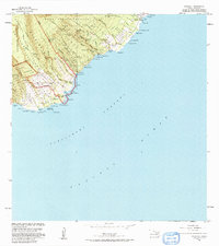
1983 Map of Kipahulu
USGS Topo · Published 1991About this map
The remote coastline of the Hana District meets the steep volcanic slopes of Haleakala National Park on this detailed coastal survey. The settlement of Kipahulu serves as a primary point of interest, situated near the Kanekaula Heiau and a local cemetery. The landscape is defined by the dramatic descent of water from the highlands, evidenced by Wailua Falls, Kekwapowai Falls, and Kanahauali Falls as they carve deep gulches toward the Alenuihaha Channel. This edition reflects the land use and protected boundaries of the early 1980s, including the Hana Forest Reserve and Kipahulu Forest Reserve. Infrastructure is minimal, consisting of a pipeline near Haou and a foot trail navigating the terrain near Palikea. Smaller coastal communities like Koali and Muolea are situated along the winding roads that skirt the numerous bays and points, such as Pepeiaolepo Bay and Kuloa Pt.
Find a feature on this map
56 named features on this map. Tap any name to fly to it.
Don’t see what you’re looking for? This feature index may not catch every label — zoom into the map to look around manually.
Map Details
Editions of this 1983 Kipahulu Map
2 editions found
Other maps of this area

1954 · Maui
USGS Topo · 1:250,000

1957 · Kipahulu
USGS Topo · 1:24,000

1957 · Hana
USGS Topo · 1:24,000

1957 · Nahiku
USGS Topo · 1:24,000

1957 · Kaupo
USGS Topo · 1:24,000

1966 · Maui
USGS Topo · 1:250,000

1974 · Maui
USGS Topo · 1:250,000

1978 · Hana
USGS Topo · 1:24,000

1983 · Nahiku
USGS Topo · 1:24,000
1983 · Kaupo
USGS Topo · 1:24,000