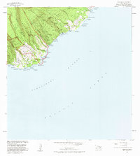
1983 Map of Kipahulu
USGS Topo · Published 1983About this map
Haleakala National Park dominates the dramatic coastal topography of southeast Maui in this early 1980s record. The landscape is defined by the steep descent of the Kipahulu Valley toward the Pacific, where numerous water features like Wailua Falls and Waimoku Falls feed into the sea. Cultural and historical sites are clustered near the shore, including a Historical Monument, multiple Heiau sites, and an Old Landing near Maulili Bay.
Find a feature on this map
91 named features on this map. Tap any name to fly to it.
Don’t see what you’re looking for? This feature index may not catch every label — zoom into the map to look around manually.
Map Details
Editions of this 1983 Kipahulu Map
2 editions found
Other maps of this area

1954 · Maui
USGS Topo · 1:250,000

1957 · Kipahulu
USGS Topo · 1:24,000

1957 · Hana
USGS Topo · 1:24,000

1957 · Nahiku
USGS Topo · 1:24,000

1957 · Kaupo
USGS Topo · 1:24,000

1966 · Maui
USGS Topo · 1:250,000

1974 · Maui
USGS Topo · 1:250,000

1978 · Hana
USGS Topo · 1:24,000

1983 · Nahiku
USGS Topo · 1:24,000
1983 · Kaupo
USGS Topo · 1:24,000