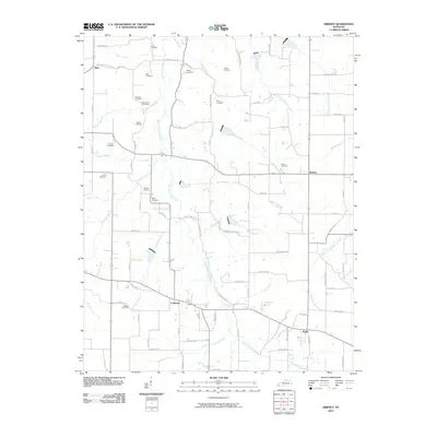
2010 Map of Kirksey
USGS Topo · Published 2010About this map
The West Fork Clarks River meanders through this agricultural landscape in Calloway County, anchoring a network of rural settlements and family cemeteries. Small community hubs like Coldwater, Kirksey, Stella, and Golo are connected by a grid of county roads, many bearing the names of local families who established themselves in the region. The map reveals an extensive genealogical record through its many burial sites, ranging from the Mount Zion Cemetery and Asbury Cemetery to smaller family plots such as the Bean Cemetery and Wyatt Cemetery. Tributaries like Damon Creek and Darnell Creek cut through the terrain, illustrating the traditional drainage patterns that have dictated local land use for generations. The abundance of named cemeteries and family-linked landmarks makes this a primary resource for tracing the 20th-century history of south-central Kentucky.
Find a feature on this map
88 named features on this map. Tap any name to fly to it.
Don’t see what you’re looking for? This feature index may not catch every label — zoom into the map to look around manually.
Map Details
Editions of this 2010 Kirksey Map
This is the sole edition of this map. No revisions or reprints were ever made.
Other maps of this area

1936 · Farmington
USGS Topo · 1:24,000

1936 · Hazel
USGS Topo · 1:24,000

1936 · Oak Level
USGS Topo · 1:24,000

1936 · Lynn Grove
USGS Topo · 1:24,000

1936 · Hardin
USGS Topo · 1:24,000

1936 · Benton
USGS Topo · 1:48,000

1936 · Westplains
USGS Topo · 1:24,000

1936 · Dexter
USGS Topo · 1:24,000

1936 · Kirksey
USGS Topo · 1:24,000
1951 · Hardin
USGS Topo · 1:24,000