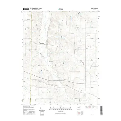
2016 Map of Kirksey
USGS Topo · Published 2016About this map
W Fork Clarks River meanders through the heart of this landscape, anchoring a rural network of small communities and family burial grounds along the Graves and Calloway county line. The settlement pattern is defined by historic crossroads like Coldwater, Backusburg, and Kirksey, where local life centered around remote churches and cemeteries. Genealogists will find a wealth of family-named landmarks including the Wyatt Cem, Collie Cem, and Bazzell Cem. The terrain is shaped by numerous tributaries such as Damon Cr, Wades Cr, and Hargrove Br, which cut through the agricultural land. In the western portion of the map, the small community of Golo sits near the Mount Olive Church, while the eastern reaches include the more modern aviation footprint of Kyle Oakley Field.
Find a feature on this map
114 named features on this map. Tap any name to fly to it.
Don’t see what you’re looking for? This feature index may not catch every label — zoom into the map to look around manually.
Map Details
Editions of this 2016 Kirksey Map
This is the sole edition of this map. No revisions or reprints were ever made.
Other maps of this area

1936 · Farmington
USGS Topo · 1:24,000

1936 · Hazel
USGS Topo · 1:24,000

1936 · Oak Level
USGS Topo · 1:24,000

1936 · Lynn Grove
USGS Topo · 1:24,000

1936 · Hardin
USGS Topo · 1:24,000

1936 · Benton
USGS Topo · 1:48,000

1936 · Westplains
USGS Topo · 1:24,000

1936 · Dexter
USGS Topo · 1:24,000

1936 · Kirksey
USGS Topo · 1:24,000
1951 · Hardin
USGS Topo · 1:24,000