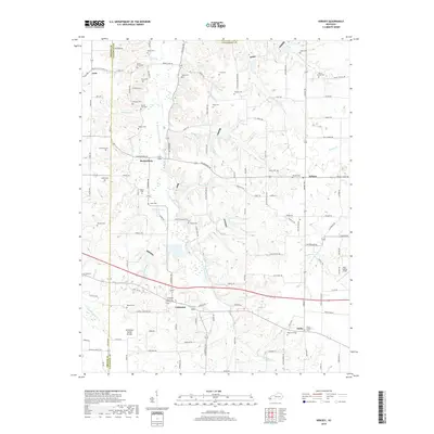
2019 Map of Kirksey
USGS Topo · Published 2019About this map
The Tennessee Valley Divide snakes through the western portion of Calloway County, defining the drainage patterns of this rural landscape where numerous small cemeteries serve as quiet markers of local lineage. Small settlements like Backusburg and Coldwater are centers of community life, with the Coldwater Church of Christ-Cem standing as a central landmark for researchers. The terrain is deeply carved by water, with the W Fork Clarks River and its various tributaries, including Sand Lick Br and Edwards Br, creating a complex network of ridges and bottoms. Along the eastern edge of the survey, the village of Kirksey and the smaller community of Stella are connected by a web of local roads such as Mount Olive Rd and Backusburg Rd. Genealogists will find a high density of family-named burial grounds, such as Collie Cem, Yandell Cem, and Waters Cem, which provide specific points of reference for tracing the area's historical inhabitants.
Find a feature on this map
124 named features on this map. Tap any name to fly to it.
Don’t see what you’re looking for? This feature index may not catch every label — zoom into the map to look around manually.
Map Details
Editions of this 2019 Kirksey Map
This is the sole edition of this map. No revisions or reprints were ever made.
Other maps of this area

1936 · Farmington
USGS Topo · 1:24,000

1936 · Hazel
USGS Topo · 1:24,000

1936 · Oak Level
USGS Topo · 1:24,000

1936 · Lynn Grove
USGS Topo · 1:24,000

1936 · Hardin
USGS Topo · 1:24,000

1936 · Benton
USGS Topo · 1:48,000

1936 · Westplains
USGS Topo · 1:24,000

1936 · Dexter
USGS Topo · 1:24,000

1936 · Kirksey
USGS Topo · 1:24,000
1951 · Hardin
USGS Topo · 1:24,000