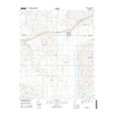
2015 Map of Kirkville
USGS Topo · Published 2015About this map
The Natchez Trace Parkway and National Scenic Trail winds through the hills of Mississippi, crossing the county line between Prentiss Co and Itawamba Co. This modern topographic perspective reveals the intersection of ancient history and 21st-century infrastructure, notably the preservation of the Pharr Mounds and Pharr Flats near the parkway's path. The settlement of Kirkville sits at the western edge, while the wide channel of the Tombigbee River and the waters of Ferguson Lake dominate the southern landscape. For genealogists, the map is a primary reference for rural burial sites, including the Kirkville Cem, Gilmore Chapel Cem, and the Ozark Cem located near Ozark Baptist Church. The terrain is defined by a dense network of tributaries like Donivan Creek and Twentymile Creek that feed into the river valley.
Find a feature on this map
66 named features on this map. Tap any name to fly to it.
Don’t see what you’re looking for? This feature index may not catch every label — zoom into the map to look around manually.
Map Details
Editions of this 2015 Kirkville Map
This is the sole edition of this map. No revisions or reprints were ever made.
Other maps of this area

1921 · Booneville
USGS Topo · 1:48,000

1921 · Tupelo
USGS Topo · 1:48,000

1922 · Booneville
USGS Topo · 1:62,500

1923 · Tupelo
USGS Topo · 1:62,500

1956 · Tupelo
USGS Topo · 1:250,000

1958 · Tupelo
USGS Topo · 1:250,000

1965 · Mooreville
USGS Topo · 1:24,000
1965 · Paden SE
USGS Topo · 1:24,000

1965 · Fulton SE
USGS Topo · 1:24,000

1965 · Fulton
USGS Topo · 1:24,000