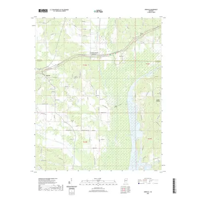
2020 Map of Kirkville
USGS Topo · Published 2020About this map
The Tombigbee River corridor defines the eastern reaches of this Mississippi landscape, where the waterway meanders past Beaver Lake and Pharr Flats. In the western uplands, the community of Kirkville serves as a local hub near the intersection of Kirkville Rd and Eliff Rd. This 2020 survey provides a detailed view of the rural settlement patterns along the Prentiss and Itawamba county line. The map is particularly useful for genealogical research, documenting numerous family and community burial grounds including Pleasant Valley Cem, Warren Cem, and the Gilmore Chapel Cem. The iconic Natchez Trace Pkwy cuts across the northern half of the quadrangle, bridging the distance between the smaller settlements of Kirkville and Sandy Springs. Hydrological features like Twentymile Creek and Donivan Creek reveal the natural drainage system that historically shaped agricultural placement in this region.
Find a feature on this map
79 named features on this map. Tap any name to fly to it.
Don’t see what you’re looking for? This feature index may not catch every label — zoom into the map to look around manually.
Map Details
Editions of this 2020 Kirkville Map
This is the sole edition of this map. No revisions or reprints were ever made.
Other maps of this area

1921 · Booneville
USGS Topo · 1:48,000

1921 · Tupelo
USGS Topo · 1:48,000

1922 · Booneville
USGS Topo · 1:62,500

1923 · Tupelo
USGS Topo · 1:62,500

1956 · Tupelo
USGS Topo · 1:250,000

1958 · Tupelo
USGS Topo · 1:250,000

1965 · Mooreville
USGS Topo · 1:24,000
1965 · Paden SE
USGS Topo · 1:24,000

1965 · Fulton SE
USGS Topo · 1:24,000

1965 · Fulton
USGS Topo · 1:24,000