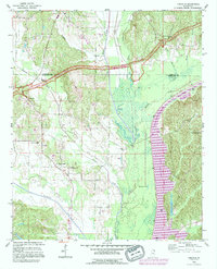
1992 Map of Kirkville
USGS Topo · Published 1995About this map
Pharr Indian Mounds stand as a significant archaeological landmark along the northern reaches of the Natchez Trace Parkway, marking a landscape where ancient history meets modern infrastructure. This 1990s revision illustrates the massive engineering of the Tennessee-Tombigbee Waterway as it cuts through the eastern half of the quadrangle, creating Beaver Lake and altering the course of the historic Tombigbee River.
Find a feature on this map
33 named features on this map. Tap any name to fly to it.
Don’t see what you’re looking for? This feature index may not catch every label — zoom into the map to look around manually.
Map Details
Editions of this 1992 Kirkville Map
This is the sole edition of this map. No revisions or reprints were ever made.
Other maps of this area

1921 · Booneville
USGS Topo · 1:48,000

1921 · Tupelo
USGS Topo · 1:48,000

1922 · Booneville
USGS Topo · 1:62,500

1923 · Tupelo
USGS Topo · 1:62,500

1956 · Tupelo
USGS Topo · 1:250,000

1958 · Tupelo
USGS Topo · 1:250,000

1965 · Mooreville
USGS Topo · 1:24,000
1965 · Paden SE
USGS Topo · 1:24,000

1965 · Fulton SE
USGS Topo · 1:24,000

1965 · Fulton
USGS Topo · 1:24,000