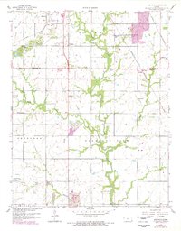
1959 Map of Kirkwood
USGS Topo · Published 1978About this map
Surface mining and small-town junctions define the landscape of south-central Kansas during this post-war era. The sheet documents a region heavily impacted by industrial excavation, with numerous Strip Mines and pits scarring the terrain between the settlements of Kirkwood and Kniveton. Local life centers around a network of country institutions, from the Council Corner Ch in the south to several small schoolhouses like Stilwell Sch and Owsley Sch that served the rural townships of Baker and Pleasant View.
Find a feature on this map
30 named features on this map. Tap any name to fly to it.
Don’t see what you’re looking for? This feature index may not catch every label — zoom into the map to look around manually.
Map Details
Editions of this 1959 Kirkwood Map
2 editions found
Other maps of this area

1886 · Joplin
USGS Topo · 1:125,000

1894 · Joplin
USGS Topo · 1:125,000

1918 · Columbus
USGS Topo · 1:62,500

1943 · Cherokee
USGS Topo · 1:62,500

1945 · Pittsburg
USGS Topo · 1:62,500

1945 · Cherokee
USGS Topo · 1:62,500

1947 · Joplin
USGS Topo · 1:250,000

1947 · Pittsburg
USGS Topo · 1:62,500

1949 · Joplin
USGS Topo · 1:250,000

1950 · Pittsburg
USGS Topo · 1:62,500