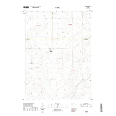
2018 Map of Kiron
USGS Topo · Published 2018About this map
The town of Kiron sits at the intersection of a complex agricultural grid, serving as a focal point where the borders of Crawford, Ida, and Sac Counties converge. This landscape is defined by the headwaters of several drainage systems, most notably the Boyer River and Otter Cr, which carve gentle valleys through the sectioned farmland. The placement of rural community markers like Bethel Cem, Kiron Cem, and Saint Johns Lutheran Cem provides a geographic record of the area's denominational and family settlement patterns. Further south, Lehfeld Cem rests near the banks of Otter Cr, illustrating how early pioneers utilized the higher ground near watercourses. The network of county highways, including Co HWY e16 and Co HWY m31, follows the township and range lines established over a century ago, maintaining the rectilinear character of this western Iowa farming region.
Find a feature on this map
45 named features on this map. Tap any name to fly to it.
Don’t see what you’re looking for? This feature index may not catch every label — zoom into the map to look around manually.
Map Details
Editions of this 2018 Kiron Map
This is the sole edition of this map. No revisions or reprints were ever made.
Other maps of this area

1954 · Fort Dodge
USGS Topo · 1:250,000

1957 · Fort Dodge
USGS Topo · 1:250,000

1958 · Fort Dodge
USGS Topo · 1:250,000

1967 · Ida Grove
USGS Topo · 1:24,000

1971 · Schleswig
USGS Topo · 1:24,000

1971 · Denison
USGS Topo · 1:24,000
1971 · Denison SW
USGS Topo · 1:24,000

1971 · Kiron
USGS Topo · 1:24,000

1980 · Odebolt East
USGS Topo · 1:24,000

1980 · Boyer
USGS Topo · 1:24,000