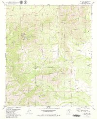
1979 Map of Kitt Peak
USGS Topo · Published 1979About this map
The Kitt Peak National Observatory dominates the high ground within the Papago Indian Reservation, housing a significant concentration of scientific infrastructure in the late 1970s. The summit is meticulously detailed with facilities including the Steward Observatory, the McMath Solar Telescope, and the Mayall Telescope (158 Inch), alongside a Heliport and a Radio Telescope. This landscape is defined by the sharp verticality of the Quinlan Mountains and Coyote Mountains, dropping into the Alambre Valley.
Find a feature on this map
50 named features on this map. Tap any name to fly to it.
Don’t see what you’re looking for? This feature index may not catch every label — zoom into the map to look around manually.
Map Details
Editions of this 1979 Kitt Peak Map
3 editions found
Other maps of this area

1920 · Arivaca
USGS Topo · 1:125,000

1934 · Tucson Mountains
USGS Topo · 1:125,000

1934 · Silver Bell
USGS Topo · 1:125,000

1938 · San Vicente
USGS Topo · 1:62,500

1940 · Palo Alto Ranch
USGS Topo · 1:62,500

1941 · San Vicente
USGS Topo · 1:62,500

1941 · Cocoraque Butte
USGS Topo · 1:62,500

1941 · Baboquivari Peak
USGS Topo · 1:62,500

1942 · San Vicente
USGS Topo · 1:62,500

1943 · Cocoraque Butte
USGS Topo · 1:62,500