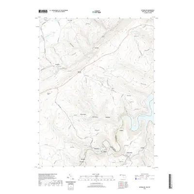
2019 Map of Kitzmiller
USGS Topo · Published 2019About this map
Kitzmiller and Blaine sit along the narrow valley floor of the North Branch Potomac River, marking a historic crossing point at the border of Maryland and West Virginia. This 2019 survey captures the rugged topography of the Allegheny Mountains, where the landscape is defined by the massive ridge of Backbone Mountain and the deep waters of Jennings Randolph Lake. The settlement patterns reflect the region's industrial and agricultural past, with small communities like Shallmar, Harrison, and West Vindex tied to the winding mountain roads and narrow creek bottoms. Genealogists will find a wealth of burial sites scattered across the ridges, including the Barnard Cem, Manor Cem, and Nethkin Cem. The presence of the Hitchcock Tunnel and roads such as Sharpless Mine Rd point to the area's long-standing connection to coal transit and extraction in the Potomac highlands.
Find a feature on this map
94 named features on this map. Tap any name to fly to it.
Don’t see what you’re looking for? This feature index may not catch every label — zoom into the map to look around manually.
Map Details
Editions of this 2019 Kitzmiller Map
This is the sole edition of this map. No revisions or reprints were ever made.
Other maps of this area

1895 · Piedmont
USGS Topo · 1:125,000

1899 · Grantsville
USGS Topo · 1:62,500

1899 · Oakland
USGS Topo · 1:62,500

1900 · Accident
USGS Topo · 1:62,500

1900 · Oakland
USGS Topo · 1:62,500

1904 · Grantsville
USGS Topo · 1:62,500

1919 · Elk Garden
USGS Topo · 1:48,000

1920 · Elk Garden
USGS Topo · 1:48,000

1922 · Elk Garden
USGS Topo · 1:62,500
1947 · Barton
USGS Topo · 1:24,000