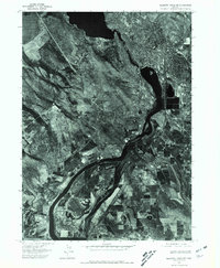
1975 Map of Klamath Falls NE
USGS Topo · Published 1981About this map
Klamath Falls appears in high-contrast detail in this 1975 orthophoto, which captures the industrial and residential footprint of the city during a period of late-century expansion. The aerial perspective reveals the dense urban grid transitioning into the broad agricultural basin of the Klamath River valley. To the south, the small settlement of Midland is visible along the primary transport corridor, surrounded by the geometric patterns of irrigated farmland. The topographic prominence of Miller Hill provides a natural landmark amidst the low-lying wetlands and reclaimed fields. This photographic record is particularly useful for observing the exact layout of lumber mills, rail yards, and riverbank development before later modern redevelopment altered the waterfront and urban periphery.
Find a feature on this map
3 named features on this map. Tap any name to fly to it.
Don’t see what you’re looking for? This feature index may not catch every label — zoom into the map to look around manually.
Map Details
Editions of this 1975 Klamath Falls NE Map
2 editions found
Other maps of this area

1889 · Klamath
USGS Topo · 1:250,000

1894 · Klamath
USGS Topo · 1:250,000

1955 · Klamath Falls
USGS Topo · 1:250,000

1957 · Merrill
USGS Topo · 1:62,500

1957 · Swan Lake
USGS Topo · 1:62,500

1957 · Klamath Falls
USGS Topo · 1:62,500

1957 · Modoc Point
USGS Topo · 1:62,500

1958 · Klamath Falls
USGS Topo · 1:250,000
1975 · Klamath Falls NE
USGS Topo · 1:24,000

1975 · Merrill NW
USGS Topo · 1:24,000