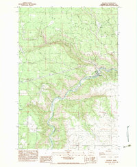
1983 Map of Klickitat
USGS Topo · Published 1983About this map
The Klickitat River snakes through a deeply incised canyon system in this 1983 survey, anchoring the industrial and residential settlement of Klickitat. The landscape is defined by the sharp contrast between the river valley and the high elevation of The Plateau, where the timber and agricultural potential of the region is evident. Industrial activity is concentrated along the water and rail corridors, featuring the Woodruff Mill to the north and a localized Logging Camp near Shippey Meadows.
Find a feature on this map
34 named features on this map. Tap any name to fly to it.
Don’t see what you’re looking for? This feature index may not catch every label — zoom into the map to look around manually.
Map Details
Editions of this 1983 Klickitat Map
This is the sole edition of this map. No revisions or reprints were ever made.
Other maps of this area

1934 · The Dalles
USGS Topo · 1:125,000

1953 · The Dalles
USGS Topo · 1:250,000

1956 · The Dalles
USGS Topo · 1:250,000

1957 · The Dalles
USGS Topo · 1:250,000

1957 · Klickitat
USGS Topo · 1:62,500

1957 · The Dalles
USGS Topo · 1:62,500

1957 · White Salmon
USGS Topo · 1:62,500

1957 · Husum
USGS Topo · 1:62,500

1974 · Stacker Butte
USGS Topo · 1:24,000

1974 · The Dalles North
USGS Topo · 1:24,000