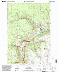
2000 Map of Klickitat
USGS Topo · Published 2003About this map
Klickitat sits at the heart of this canyon-cut landscape, where the Klickitat River carves a deep path through the volcanic basalt of the region. This 2000-era revision, based on imagery from the late 1990s, documents the town and the surrounding Klickitat State Wildlife Area before major modern landscape changes. The terrain is defined by dramatic elevation shifts, from the high elevation of The Plateau down through numerous drainages like Sheep Corral Canyon and Skookum Canyon. Industrial and agricultural history is marked by the presence of Woodruff Mill and the Klickitat-Appleton Road, which provides access to more remote areas like Shippeys Meadows. Along the river, infrastructure including Gaging Station 269 and a private road indicates the managed nature of this Klickitat Wild and Scenic River corridor.
Find a feature on this map
33 named features on this map. Tap any name to fly to it.
Don’t see what you’re looking for? This feature index may not catch every label — zoom into the map to look around manually.
Map Details
Editions of this 2000 Klickitat Map
This is the sole edition of this map. No revisions or reprints were ever made.
Other maps of this area

1934 · The Dalles
USGS Topo · 1:125,000

1953 · The Dalles
USGS Topo · 1:250,000

1956 · The Dalles
USGS Topo · 1:250,000

1957 · The Dalles
USGS Topo · 1:250,000

1957 · Klickitat
USGS Topo · 1:62,500

1957 · The Dalles
USGS Topo · 1:62,500

1957 · White Salmon
USGS Topo · 1:62,500

1957 · Husum
USGS Topo · 1:62,500

1974 · Stacker Butte
USGS Topo · 1:24,000

1974 · The Dalles North
USGS Topo · 1:24,000