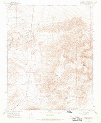
1967 Map of Klinker Mountain
USGS Topo · Published 1968About this map
The Lava Mountains and the Summit Range dominate this desert landscape, characterized by isolated water sources and industrial infrastructure in the mid-1960s. Mining activity is prevalent throughout the northwestern sector, where numerous Mines and a Gravel Pit appear alongside the Southern Pacific railroad line and Searles Station. Evidence of early human presence is documented by Petroglyphs located near the southern peaks, while the more modern needs of the region are reflected in the prominent Aqueduct, Pipeline, and the north-south route of Trona Road. Water management in this arid terrain is further highlighted by a network of named points such as Mountain Well, Skilling Well, Dry Well, and Steam Well scattered across the lower elevations near Red Mountain.
Find a feature on this map
27 named features on this map. Tap any name to fly to it.
Don’t see what you’re looking for? This feature index may not catch every label — zoom into the map to look around manually.
Map Details
Editions of this 1967 Klinker Mountain Map
2 editions found
Other maps of this area

1903 · Randsburg
USGS Topo · 1:62,500

1911 · Randsburg
USGS Topo · 1:62,500

1912 · Randsburg
USGS Topo · 1:62,500

1915 · Searles Lake
USGS Topo · 1:250,000

1947 · Trona
USGS Topo · 1:250,000

1948 · Trona
USGS Topo · 1:250,000

1949 · Searles Lake
USGS Topo · 1:62,500

1950 · Searles Lake
USGS Topo · 1:62,500

1953 · Ridgecrest
USGS Topo · 1:62,500

1953 · Trona
USGS Topo · 1:250,000