
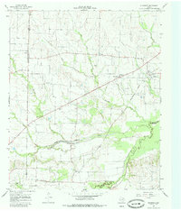
1964 Map of Klondike
USGS Topo · Published 1968About this map
The Southern Pacific railroad line cuts a diagonal path through this agricultural landscape, linking the small community of Klondike to the broader regional economy in the mid-1960s. This survey illustrates a network of rural settlements like Yowell, Needmore, and Horton, where life centered around local institutions such as Shiloh Ch and the Wintermute Mem Hosp. The terrain is defined by the convergence of the Middle Sulphur River and the South Sulphur River, creating a well-watered basin carved by numerous tributaries including Honey Creek and Jernigan Creek.
Find a feature on this map
25 named features on this map. Tap any name to fly to it.
Don’t see what you’re looking for? This feature index may not catch every label — zoom into the map to look around manually.
Map Details
Editions of this 1964 Klondike Map
2 editions found
Other maps of this area

1953 · Texarkana
USGS Topo · 1:250,000

1956 · Texarkana
USGS Topo · 1:250,000

1964 · Cumby
USGS Topo · 1:24,000

1964 · Commerce South
USGS Topo · 1:24,000

1964 · Gafford Chapel
USGS Topo · 1:24,000

1964 · Commerce North
USGS Topo · 1:24,000

1964 · Cooper North
USGS Topo · 1:24,000

1964 · Ladonia
USGS Topo · 1:24,000

1964 · Pecan Gap
USGS Topo · 1:24,000
1964 · Cooper South
USGS Topo · 1:24,000