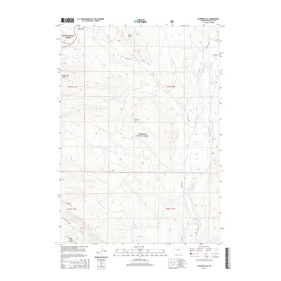
2015 Map of Klondike Hill
USGS Topo · Published 2015About this map
Kendall Warm Spring, Warm Spring, and the sulfurous Stinky Spring emerge along the eastern bank of the Green River, defining a geothermal landscape in the heart of the Bridger National Forest. The 2015 survey reveals a high-altitude wilderness shaped by prominent terrain features such as Bacon Ridge to the north and the namesake Klondike Hill at the center of the sheet. Remote aviation and transport are represented by the Kinky Creek Divide Airport and the historic route of Union Pass Rd. A dense network of drainage systems, including Tosi Cr and Klondike Cr, flows toward the Green River, which meanders through the Big Bend area. This document provides a record of the wilderness boundary between the Teton National Forest and its southern neighbor, highlighting landmarks like the Rock Creek Buttes and Dollar Lake.
Find a feature on this map
34 named features on this map. Tap any name to fly to it.
Don’t see what you’re looking for? This feature index may not catch every label — zoom into the map to look around manually.
Map Details
Editions of this 2015 Klondike Hill Map
This is the sole edition of this map. No revisions or reprints were ever made.
Other maps of this area

1907 · Gros Ventre
USGS Topo · 1:125,000

1909 · Fremont Peak
USGS Topo · 1:125,000

1910 · Gros Ventre
USGS Topo · 1:125,000

1955 · Driggs
USGS Topo · 1:250,000

1955 · Thermopolis
USGS Topo · 1:250,000

1958 · Driggs
USGS Topo · 1:250,000

1958 · Thermopolis
USGS Topo · 1:250,000

1962 · Thermopolis
USGS Topo · 1:250,000

1962 · Driggs
USGS Topo · 1:250,000
1966 · Pass Peak
USGS Topo · 1:24,000