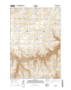
2014 Map of Klondike
USGS Topo · Published 2014About this map
Klondike sits as the central point of interest in this Sherman County landscape, an area defined by deep drainage patterns and volcanic topography. The terrain is marked by significant features like Beavertrail Butte and the winding course of Spanish Hollow. The map reveals a highly structured grid of section lines and rural routes, including Baseline LN and Mcdonald Ferry LN, which speak to the region's agricultural and transit heritage. To the north, Emigrant Springs provides a rare water source amidst the complex network of canyons such as Biglow Canyon, Hay Canyon, and Draper Canyon. This 2014 survey by the U.S. Geological Survey captures the modern rural layout of a region historically tied to the Oregon Trail and the wheat-growing plateaus above the Columbia River.
Find a feature on this map
29 named features on this map. Tap any name to fly to it.
Don’t see what you’re looking for? This feature index may not catch every label — zoom into the map to look around manually.
Map Details
Editions of this 2014 Klondike Map
This is the sole edition of this map. No revisions or reprints were ever made.
Other maps of this area

1916 · Arlington
USGS Topo · 1:125,000

1916 · Condon
USGS Topo · 1:125,000

1953 · The Dalles
USGS Topo · 1:250,000

1956 · The Dalles
USGS Topo · 1:250,000

1957 · The Dalles
USGS Topo · 1:250,000

1957 · Wasco
USGS Topo · 1:62,500

1964 · Mc Donald
USGS Topo · 1:24,000
1970 · Esau Canyon
USGS Topo · 1:24,000

1971 · Moro
USGS Topo · 1:24,000

1971 · Quinton
USGS Topo · 1:24,000