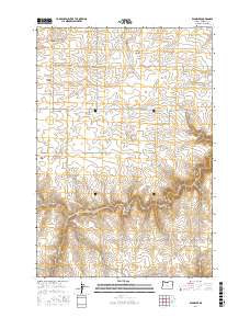
2017 Map of Klondike
USGS Topo · Published 2017About this map
Klondike is the central settlement in this portion of Sherman County, situated on the high plateau between deep drainages. The landscape is defined by the sharp descent from level fields into a network of steep coulees, including Biglow Canyon, Draper Canyon, and Emigrant Canyon. These erosional features cut through the terrain toward the north, while Spanish Hollow and Grass Valley Canyon define the southern and eastern edges. This topography created a challenging environment for early travelers, as evidenced by the namesake Emigrant Springs in the northern reaches of the quadrangle. High points like Beavertrail Butte rise above the surrounding agricultural lands, while the road network follows historic corridors such as the Old Wasco-Heppner Hwy. The area is characterized by large sectioned tracts and a series of rural lanes like Rayburn Rd and Webfoot Rd that navigate the ridges between the canyons.
Find a feature on this map
30 named features on this map. Tap any name to fly to it.
Don’t see what you’re looking for? This feature index may not catch every label — zoom into the map to look around manually.
Map Details
Editions of this 2017 Klondike Map
This is the sole edition of this map. No revisions or reprints were ever made.
Other maps of this area

1916 · Arlington
USGS Topo · 1:125,000

1916 · Condon
USGS Topo · 1:125,000

1953 · The Dalles
USGS Topo · 1:250,000

1956 · The Dalles
USGS Topo · 1:250,000

1957 · The Dalles
USGS Topo · 1:250,000

1957 · Wasco
USGS Topo · 1:62,500

1964 · Mc Donald
USGS Topo · 1:24,000
1970 · Esau Canyon
USGS Topo · 1:24,000

1971 · Moro
USGS Topo · 1:24,000

1971 · Quinton
USGS Topo · 1:24,000