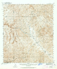
1938 Map of Klondyke
USGS Topo · Published 1964About this map
Klondyke and the surrounding high desert canyon country of the Santa Teresa Mountains define this late-1930s topographic study. The settlement of Copper Creek sits at the southwestern edge of the quadrangle, serving as a hub for intense local extraction efforts evidenced by the Copper Prince Mine, Glory Hole Mine, and Reliable Mine. These industrial points are connected by a network of trails and primitive roads that navigate the complex drainage systems of Aravaipa Creek and Cottonwood Creek.
Find a feature on this map
43 named features on this map. Tap any name to fly to it.
Don’t see what you’re looking for? This feature index may not catch every label — zoom into the map to look around manually.
Map Details
Editions of this 1938 Klondyke Map
3 editions found
Other maps of this area

1911 · Winkelman
USGS Topo · 1:125,000

1913 · Winkelman
USGS Topo · 1:125,000

1915 · Christmas
USGS Topo · 1:62,500

1917 · Christmas
USGS Topo · 1:62,500

1938 · Galiuro Mts
USGS Topo · 1:48,000

1938 · Klondyke
USGS Topo · 1:48,000

1940 · Sierra Bonita Ranch
USGS Topo · 1:62,500

1942 · Sierra Bonita Ranch
USGS Topo · 1:62,500

1943 · Galiuro Mts
USGS Topo · 1:62,500

1943 · Klondyke
USGS Topo · 1:62,500