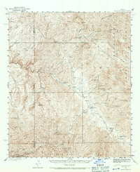
1938 Map of Klondyke
USGS Topo · Published 1971About this map
Aravaipa Creek cuts a vital path through this high-desert landscape, providing the lifeblood for the small community of Klondyke and the nearby Aravaipa Sch. Surveyed in the late 1930s, the map reveals a region defined by an intense mineral extraction economy. Hardrock mining operations are scattered across the peaks and canyons, from the Grand Reef Mine on the slopes of the Santa Teresa Mountains to the concentrated activity at Copper Creek in the southwest, where the Glory Hole Mine and Copper Prince Mine are located.
Find a feature on this map
42 named features on this map. Tap any name to fly to it.
Don’t see what you’re looking for? This feature index may not catch every label — zoom into the map to look around manually.
Map Details
Editions of this 1938 Klondyke Map
3 editions found
Other maps of this area

1911 · Winkelman
USGS Topo · 1:125,000

1913 · Winkelman
USGS Topo · 1:125,000

1915 · Christmas
USGS Topo · 1:62,500

1917 · Christmas
USGS Topo · 1:62,500

1938 · Galiuro Mts
USGS Topo · 1:48,000

1938 · Klondyke
USGS Topo · 1:48,000

1940 · Sierra Bonita Ranch
USGS Topo · 1:62,500

1942 · Sierra Bonita Ranch
USGS Topo · 1:62,500

1943 · Galiuro Mts
USGS Topo · 1:62,500

1943 · Klondyke
USGS Topo · 1:62,500