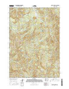
2017 Map of Kloster Mountain
USGS Topo · Published 2017About this map
Kloster Mountain and the surrounding Lane County peaks define a landscape of high ridges and drainage basins in this 2017 survey. The terrain is marked by a complex network of forest access routes, including Smith Creek Rd and Guiley Creek Rd, which follow the deep valleys carved by Smith Cr and Guiley Cr. To the south, Buckhorn Mtn stands as a prominent topographical landmark near Noyas Pass.
Find a feature on this map
36 named features on this map. Tap any name to fly to it.
Don’t see what you’re looking for? This feature index may not catch every label — zoom into the map to look around manually.
Map Details
Editions of this 2017 Kloster Mountain Map
This is the sole edition of this map. No revisions or reprints were ever made.
Other maps of this area

1935 · Lowell
USGS Topo · 1:96,000

1942 · Lowell
USGS Topo · 1:125,000

1955 · Hardesty Mtn
USGS Topo · 1:62,500

1955 · Fairview Peak
USGS Topo · 1:62,500

1955 · Culp Creek
USGS Topo · 1:62,500

1955 · Lowell
USGS Topo · 1:62,500

1958 · Roseburg
USGS Topo · 1:250,000

1959 · Roseburg
USGS Topo · 1:250,000

1983 · Oakridge
USGS Topo · 1:100,000
1986 · Blue Mountain
USGS Topo · 1:24,000