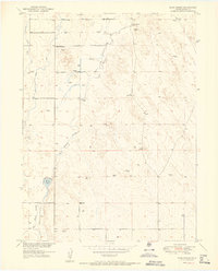
1951 Map of Klug Ranch
USGS Topo · Published 1951About this map
Klug Ranch and its surrounding high plains landscape define this 1950s-era topographic study of eastern Weld County. The area is characterized by a sparse but deliberate network of water management features, including Klug Lake and numerous well and windmill sites that supported livestock and agriculture in this arid environment. The intermittent course of Elder Box Creek winds through the terrain, which is otherwise marked by subtle elevations like Box Elder. Social and educational life in this rural precinct centered on the Sky View School, located in the northwest quadrant. The map provides a clear look at the mid-century infrastructure of the Colorado plains, where section lines and dirt roads dictate the movement of people and resources between the isolated ranching outposts.
Find a feature on this map
8 named features on this map. Tap any name to fly to it.
Don’t see what you’re looking for? This feature index may not catch every label — zoom into the map to look around manually.
Map Details
Editions of this 1951 Klug Ranch Map
2 editions found
Other maps of this area

1902 · Greeley
USGS Topo · 1:125,000

1949 · Hudson
USGS Topo · 1:24,000

1950 · Tampa
USGS Topo · 1:24,000

1950 · Keenesburg
USGS Topo · 1:24,000

1950 · Prospect Valley
USGS Topo · 1:24,000

1950 · Klug Ranch
USGS Topo · 1:24,000

1950 · Valley View School
USGS Topo · 1:24,000

1950 · Hardin
USGS Topo · 1:24,000
1950 · Milton Reservoir
USGS Topo · 1:24,000

1950 · La Salle
USGS Topo · 1:24,000