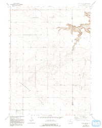
1963 Map of Klutz Canyon
USGS Topo · Published 1993About this map
Slater Flats and Chugwater Flats dominate this landscape, illustrating the plateau-like character of the region along the Platte and Goshen County line. The terrain is dramatically interrupted by a series of deep drainages, most notably Klutz Canyon and its namesake Klutz Springs, which cut into the Goshen Hole depression. This transition from the flat agricultural plains of Iowa Center Flats to the complex canyon systems of Box Elder Canyon and Cedar Canyon highlights the area's geological variety. Local community life is anchored at the southern edge of the sheet by the Town Center Flats Ch and a nearby Cem, reflecting a pattern of rural settlement common to the high plains in the mid-20th century. Scattered Spring labels across the canyons suggest the importance of natural water sources for ranching operations in these drier breaks.
Find a feature on this map
18 named features on this map. Tap any name to fly to it.
Don’t see what you’re looking for? This feature index may not catch every label — zoom into the map to look around manually.
Map Details
Editions of this 1963 Klutz Canyon Map
2 editions found
Other maps of this area

1953 · Chugwater
USGS Topo · 1:24,000

1953 · Bordeaux
USGS Topo · 1:24,000

1954 · Cheyenne
USGS Topo · 1:250,000

1958 · Cheyenne
USGS Topo · 1:250,000

1962 · Bristol Ridge NE
USGS Topo · 1:24,000
1963 · Dickinson Hill
USGS Topo · 1:24,000

1963 · C S Ranch
USGS Topo · 1:24,000

1963 · Y B O Canyon
USGS Topo · 1:24,000

1963 · Klutz Canyon
USGS Topo · 1:24,000
1963 · Glomill Reservoir
USGS Topo · 1:24,000