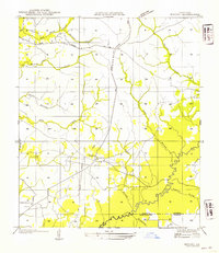
1954 Map of Knight
USGS Topo · Published 1954About this map
Knight and Fal anchor this rural landscape in the mid-1930s, reflecting a community structured around the logging industry and small-scale agriculture. The infrastructure is dominated by the Logging Railroad Grade and an Old Logging Railroad Grade, indicating a region that had already transitioned through its peak timber extraction phase. Local life centers on spiritual landmarks like Mt Carmel Ch and Bethel Grove Ch, which served dispersed homesteads along the network of creeks and branches. A complex drainage system defines the terrain, with Anacoco Bayou winding across the southern boundary near the Vernon Parish and Beauregard Parish line. Numerous watercourses, such as Red Bank Creek, Damrel Creek, and Mill Creek, suggest the importance of these natural features for early settlement patterns and possible milling sites before the modernization of State Highway No 512.
Find a feature on this map
20 named features on this map. Tap any name to fly to it.
Don’t see what you’re looking for? This feature index may not catch every label — zoom into the map to look around manually.
Map Details
Editions of this 1954 Knight Map
This is the sole edition of this map. No revisions or reprints were ever made.
Other maps of this area

1941 · Leesville
USGS Topo · 1:62,500

1943 · Leesville
USGS Topo · 1:62,500

1944 · Wiergate
USGS Topo · 1:62,500

1946 · Leesville
USGS Topo · 1:62,500

1946 · Merryville
USGS Topo · 1:31,680

1947 · Pujo
USGS Topo · 1:31,680

1947 · DeRidder
USGS Topo · 1:31,680

1947 · Rosepine
USGS Topo · 1:31,680

1947 · Knight
USGS Topo · 1:31,680

1948 · Leesville
USGS Topo · 1:62,500