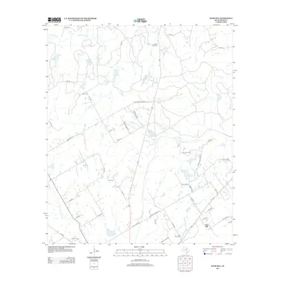
2012 Map of Knob Hill
USGS Topo · Published 2012About this map
N Paluxy River and the S Paluxy River frame a landscape of family-named cemeteries and agricultural roads in Erath County. This 2012 survey documents the rural character surrounding the Knob Hill settlement, where the terrain is marked by the eponymous Knob Hill summit and the Knob Hill Cem. Small water bodies such as Terrell Lake and the paired Bonham Lake Number 1 and Bonham Lake Number 2 indicate a managed water system typical of Texas ranching country. For genealogists, the map preserves the exact locations of burial grounds including Morton Chapel Cem, Bethel Cem, Wright Cem, and Smith Springs Cem. These landmarks, along with many county roads like Farm-To-Market Road 3025, show the enduring grid of local travel and community life in this part of north-central Texas.
Find a feature on this map
55 named features on this map. Tap any name to fly to it.
Don’t see what you’re looking for? This feature index may not catch every label — zoom into the map to look around manually.
Map Details
Editions of this 2012 Knob Hill Map
This is the sole edition of this map. No revisions or reprints were ever made.
Other maps of this area

1890 · Stephenville
USGS Topo · 1:125,000

1920 · Stephenville
USGS Topo · 1:125,000

1954 · Abilene
USGS Topo · 1:250,000

1958 · Abilene
USGS Topo · 1:250,000

1961 · Johnsville
USGS Topo · 1:24,000

1961 · Knob Hill
USGS Topo · 1:24,000

1961 · Stephenville
USGS Topo · 1:24,000
1965 · Bluff Dale NE
USGS Topo · 1:24,000
1965 · Bunyan
USGS Topo · 1:24,000
1965 · Huckabay
USGS Topo · 1:24,000