
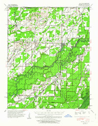
1941 Map of Knobel
USGS Topo · Published 1946About this map
Black River meanders through the heart of this Clay County landscape, creating a complex network of wetlands and oxbows like Old River Lake and Thwait Back Out. The settlement pattern follows the high ground and the paths of the Missouri Pacific RR and St Louis San Francisco RR. At the railway junctions, towns such as Knobel and Corning serve as local hubs, while smaller communities like Peach Orchard and Moark are nestled near the state line.
Find a feature on this map
108 named features on this map. Tap any name to fly to it.
Don’t see what you’re looking for? This feature index may not catch every label — zoom into the map to look around manually.
Map Details
Editions of this 1941 Knobel Map
2 editions found
Other maps of this area

1932 · Walnut Ridge
USGS Topo · 1:62,500

1935 · Acorn
USGS Topo · 1:62,500

1935 · Rector
USGS Topo · 1:62,500

1935 · Knobel
USGS Topo · 1:62,500

1935 · Reyno
USGS Topo · 1:62,500

1935 · Harviell
USGS Topo · 1:62,500

1935 · Walnut Ridge
USGS Topo · 1:62,500

1939 · Doniphan
USGS Topo · 1:62,500

1940 · Naylor
USGS Topo · 1:62,500

1940 · Gainesville
USGS Topo · 1:62,500