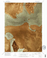
1973 Map of Knolls SE
USGS Topo · Published 1977About this map
The Wendover Air Force Range dominates this orthophotomap, showing the stark intersection of military operations and the desert geography of the Great Salt Lake Desert. The aerial-based imagery emphasizes the interplay between the vast Mud Flat areas and the distinct, textured patterns of Shifting Sand that migrate across the basin floor. Unlike traditional line-drawn maps, this 1970s orthophotomosaic provides a direct photographic record of the land surface as it appeared during intensive military use of the region. The lack of permanent structures and the prevalence of ephemeral terrain features underscore the isolation and environmental specialized utility of this portion of Tooele County.
Find a feature on this map
3 named features on this map. Tap any name to fly to it.
Don’t see what you’re looking for? This feature index may not catch every label — zoom into the map to look around manually.
Map Details
Editions of this 1973 Knolls SE Map
2 editions found
Other maps of this area

1953 · Tooele
USGS Topo · 1:250,000

1954 · Wildcat Mtn
USGS Topo · 1:24,000

1954 · Wig Mtn NW
USGS Topo · 1:24,000

1955 · Tooele
USGS Topo · 1:250,000

1973 · Knolls SW
USGS Topo · 1:24,000

1973 · Wildcat Mountain NW
USGS Topo · 1:24,000

1973 · Knolls
USGS Topo · 1:24,000

1973 · Aragonite NW
USGS Topo · 1:24,000

1973 · Barro
USGS Topo · 1:24,000

1973 · Knolls SE
USGS Topo · 1:24,000