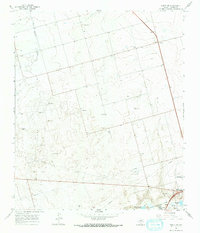
1966 Map of Knott SE
USGS Topo · Published 1968About this map
Webb Air Force Base occupies the southeastern corner of this West Texas landscape, marking a period of significant military activity in Howard County during the mid-1960s. The terrain is characterized by a sprawling Oil Field network, with numerous wells and access roads crisscrossing the plains between Buzzard Draw and the saline waters of Threemile Lake (Salt). This industrial footprint is punctuated by local centers of community life, such as Fairview and Prairie View Ch. Near the southern edge, the Big Spring State Hospital and the Texas and Pacific railroad indicate the regional importance of this area as a hub for both public services and heavy transportation. The map captures an era of resource extraction and defense infrastructure before later shifts in the petroleum economy and base closures altered the local geography.
Find a feature on this map
18 named features on this map. Tap any name to fly to it.
Don’t see what you’re looking for? This feature index may not catch every label — zoom into the map to look around manually.
Map Details
Editions of this 1966 Knott SE Map
2 editions found

Other maps of this area

1941 · Morita
USGS Topo · 1:62,500

1941 · Big Spring South
USGS Topo · 1:62,500

1942 · Big Spring South
USGS Topo · 1:62,500

1942 · Big Spring North
USGS Topo · 1:62,500

1949 · Morita
USGS Topo · 1:62,500

1954 · Big Spring
USGS Topo · 1:250,000

1954 · Big Spring North
USGS Topo · 1:24,000

1958 · Big Spring
USGS Topo · 1:250,000

1965 · Big Spring North
USGS Topo · 1:24,000

1966 · Knott
USGS Topo · 1:24,000