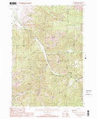
1988 Map of Knowles Peak
USGS Topo · Published 1988About this map
Gallatin National Forest dominates this mountain landscape, which was documented during the mid-1980s. The drainage of Mill Creek serves as a central artery for the region, where various recreational and ranching outposts like Snowy Range Ranch and Mill Creek Ranch are situated near the Wilderness Boundary. Evidence of small-scale resource extraction appears through the Barbara Ann Mine and a Strip Mine located near Flat DITCH in the northwestern corner.
Find a feature on this map
33 named features on this map. Tap any name to fly to it.
Don’t see what you’re looking for? This feature index may not catch every label — zoom into the map to look around manually.
Map Details
Editions of this 1988 Knowles Peak Map
3 editions found
Other maps of this area

1891 · Livingston
USGS Topo · 1:250,000

1893 · Livingston
USGS Topo · 1:250,000

1940 · Mt. Cowen
USGS Topo · 1:62,500

1940 · Mt Wallace
USGS Topo · 1:62,500

1943 · Mt Wallace
USGS Topo · 1:62,500

1943 · Mt Cowen
USGS Topo · 1:62,500

1947 · Bozeman
USGS Topo · 1:250,000

1948 · Bozeman
USGS Topo · 1:250,000

1955 · Bozeman
USGS Topo · 1:250,000

1955 · Emigrant
USGS Topo · 1:62,500