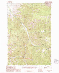
1988 Map of Knowles Peak
USGS Topo · Published 1988About this map
Gallatin National Forest dominates this mountain landscape, where deep creek drainages converge near the high peaks of the Absaroka-Beartooth Wilderness. The map reveals a specialized local economy centered on high-altitude ranching and mineral extraction during the late 1980s. Working landscapes like Snowy Range Ranch and Mill Creek Ranch sit at the edge of the wilderness, while evidence of mining activity is preserved at the Barbara Ann Mine and a Strip Mine near Davis Creek. The topography is defined by prominent landmarks such as Knowles Peak, Arrow Peak, and the distinctive Castle Rock. Water sources are abundant, from the thermal or mineral suggestions of Montanapolis Springs to the branching forks of Mill Creek, including the West Fork Mill Creek and East Fork Mill Creek.
Find a feature on this map
33 named features on this map. Tap any name to fly to it.
Don’t see what you’re looking for? This feature index may not catch every label — zoom into the map to look around manually.
Map Details
Editions of this 1988 Knowles Peak Map
3 editions found
Other maps of this area

1891 · Livingston
USGS Topo · 1:250,000

1893 · Livingston
USGS Topo · 1:250,000

1940 · Mt. Cowen
USGS Topo · 1:62,500

1940 · Mt Wallace
USGS Topo · 1:62,500

1943 · Mt Wallace
USGS Topo · 1:62,500

1943 · Mt Cowen
USGS Topo · 1:62,500

1947 · Bozeman
USGS Topo · 1:250,000

1948 · Bozeman
USGS Topo · 1:250,000

1955 · Bozeman
USGS Topo · 1:250,000

1955 · Emigrant
USGS Topo · 1:62,500